|

BANGLADESH, relatively small coastal country of south central Asia. The capital is Dhaka(Formally spelled dacca).
Bangladesh (Land of Bengalis) is an independent Asian state located in south Asia, the delta of Ganges and
Jamuna (Brahmputra) rivers in the northestern part of the Indian subcontinent.(The Largest Delta in the World) The countrys
official name is the Peoples Republic of Bangladesh from 1947 until 1947 It was, as East Pakistan, separated from the other
four by 1,100 miles(1,800 kilometers)of Indian territory.
This is Prime Minister Office Of Bangladesh

About Bangladesh
Bangladeh declared its independence in 26th of March 1971,and won the freedom war in 16th of December same year(1971)
Bangladesh ,is a riverine country.It has an area of 55,598 square miles(143,998 square kilometers) and is one of the
most densely populated countries in the world. Bangladesh is a bounded by India to the west and north,Myanmer(Burma) to the
southest ,and the Bay of Bangal to the south. The country lies between latitudes 2034' and 2638' N (about 390 miles [625 km]
from its extreme north
and south extensions) and between longitudes 8801' and 9241' E (about 190 miles [305 km] from
east
to west). To the south Bangladesh has an irregular coastline fronting the Bay of Bengal.
Area 56,977 square
miles (147,570 square km).
Pop. (1996 est.) 123,063,000.
Bangladesh's low-lying landscape is dominated
by the confluence of the Ganges (or Padma, as the united
streams of the Ganges and Brahmaputra are known), the Brahmaputra
(Jamuna), and the Meghna river
systems, which empty into the Bay of Bengal. Bangladesh constitutes the eastern two-thirds
of the
Ganges-Brahmaputra deltaic plain, stretches northward to include the triangular wedge of land between
the
Ganges and the Brahmaputra above their confluence, and extends eastward to embrace the valley
plain of the Surma River.
Farther east the alluvial plains give place to ridges running mainly north-south
that form part of the mountain divide
with Myanmar in the southeast.
Excepting small higher areas of old alluvium, the whole plain is a flat surface of new
alluvium, having a
very gentle slope, generally with an elevation of less than 30 feet (9 m) above sea level. More than
90
percent of the area of Bangladesh is composed of plains. Lakes, swamps, and marshes form the other
important
aspect of the amphibious landscape. On the flatlands, rivers divide and subdivide themselves
into numerous distributaries
with raised banks. Hundreds of square miles of land are flooded during the
monsoon season.
South-central Bangladesh
comprises an old western delta, with dead and decaying rivers, and the eastern
new delta, with active rivers carrying
on depositional or constructive work. The southern coastal belt, which
carries the mangrove forests (Sundarbans), is
a salt marsh. The narrow southeastern coastal belt near
Noakhali and Chittagong is formed of both old and recent alluvium.
East of the southeastern coastal belt
lies the hilly area called the Chittagong Hill Tracts, which consists of low hills
of soft rocks, mainly clay and
shale. Its north-south ranges are generally below 2,000 feet (610 m) in height, the highest
peak,
Keokradong, rising to 3,041 feet (927 m).
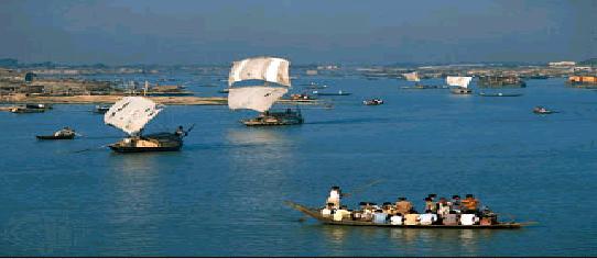
See The River Scene

|
|
Bangladeh declared its independence in 26th of March 1971,and won the freedom war in 16th of December same year(1971)
Bangladesh ,is a riverine country.It has an area of 55,598 square miles(143,998 square kilometers) and is one of the
most densely populated countries in the world. Bangladesh is a bounded by India to the west and north,Myanmer(Burma) to the
southest ,and the Bay of Bangal to the south. The country lies between latitudes 2034' and 2638' N (about 390 miles [625 km]
from its extreme north
and south extensions) and between longitudes 8801' and 9241' E (about 190 miles [305 km] from
east
to west). To the south Bangladesh has an irregular coastline fronting the Bay of Bengal.
Area 56,977 square
miles (147,570 square km).
Pop. (1996 est.) 123,063,000.
Bangladesh's low-lying landscape is dominated
by the confluence of the Ganges (or Padma, as the united
streams of the Ganges and Brahmaputra are known), the Brahmaputra
(Jamuna), and the Meghna river
systems, which empty into the Bay of Bengal. Bangladesh constitutes the eastern two-thirds
of the
Ganges-Brahmaputra deltaic plain, stretches northward to include the triangular wedge of land between
the
Ganges and the Brahmaputra above their confluence, and extends eastward to embrace the valley
plain of the Surma River.
Farther east the alluvial plains give place to ridges running mainly north-south
that form part of the mountain divide
with Myanmar in the southeast.
Excepting small higher areas of old alluvium, the whole plain is a flat surface of new
alluvium, having a
very gentle slope, generally with an elevation of less than 30 feet (9 m) above sea level. More than
90
percent of the area of Bangladesh is composed of plains. Lakes, swamps, and marshes form the other
important
aspect of the amphibious landscape. On the flatlands, rivers divide and subdivide themselves
into numerous distributaries
with raised banks. Hundreds of square miles of land are flooded during the
monsoon season.
South-central Bangladesh
comprises an old western delta, with dead and decaying rivers, and the eastern
new delta, with active rivers carrying
on depositional or constructive work. The southern coastal belt, which
carries the mangrove forests (Sundarbans), is
a salt marsh. The narrow southeastern coastal belt near
Noakhali and Chittagong is formed of both old and recent alluvium.
East of the southeastern coastal belt
lies the hilly area called the Chittagong Hill Tracts, which consists of low hills
of soft rocks, mainly clay and
shale. Its north-south ranges are generally below 2,000 feet (610 m) in height, the highest
peak,
Keokradong, rising to 3,041 feet (927 m).
Climate
The climate and hydrology of Bangladesh
are dramatically affected by the annual monsoon season (June
through October); three-quarters of the country's precipitation
occurs during this five-month period.
During the monsoon season many rivers overflow their banks and inundate the countryside;
these floods
deposit fertile silt on the nation's farmland. The hydrology of the Chittagong highlands is also important
because the power plant at the Karnaphuli dam (forming the Karnaphuli Reservoir) provides much of the
country's
hydroelectric capacity. Annual rates of precipitation vary from a low of 40 to 80 inches (1,000 to
2,000 mm) in the
western lowlands to more than 150 inches in the Sylhet Hills in the northeast. The
temperature varies generally between
70 F (21 C) in the winter and 95 F (35 C) in the summer. In the
early summer (April and May) and late in the monsoon
season, high-intensity storms, including cyclones.
Land
More than two-thirds of Bangladesh's land is
considered arable and lies primarily in the lowland regions;
one-fifth is irrigated. Forests cover about one-sixth of
the country. Plant and animal life includes royal
Bengal tigers, clouded leopards, and Asian elephants, all endangered
species.
People
The vast majority of the country's population are Bengalis, who speak an eastern Indo-Aryan
language
related to Sanskrit. More than four-fifths of the population are Muslims of the Sunnite sect, and about
one-tenth
are Hindus. The Chittagong Hill Tracts in southeastern Bangladesh are inhabited largely by tribal
peoples, including
the Chakma, the Marma, the Tripura (Tipra), and the Mro, who are predominantly
Buddhists.
Bangladesh is
one of the most densely populated countries in the world, with the highest
densities occurring in and around the capital
city of Dhaka. It is also a predominantly rural country, with
only about one-fourth of the population living in urban
areas. Rural areas are often so thickly settled that
it is difficult to distinguish any well-defined pattern of individual
villages. Bangladesh has a rather high rate
of population growth, and almost one-half of the population is under 15
years of age. Both birth and
death rates are far above world averages. Life expectancy at birth is only about 56 years
for both males
and females.
Economy
Bangladesh has a developing mixed economy that is heavily based
upon agriculture. Almost two-fifths of
the gross domestic product (GDP) originates from agriculture, followed by services,
and transportation and
communication.
Cereals, principally rice as well as wheat, are the main crops, occupying
most of the cultivated land.
Sugarcane, jute, pulses, fruits (bananas, mangoes, and pineapples), roots and tubers, and
vegetables are
also grown. Other crops include tobacco, sesame seed, and tea. The principal livestock are cattle (including
some dairy cattle), goats, water buffalo, and sheep.
Coastal waters of the Bay of Bengal offer excellent
marine fishing, and Bangladesh's innumerable rivers,
estuaries, and swamps are ideally suited for freshwater fishing,
yielding most of the total catch.
Natural gas is the country's richest mineral resource, though still minor
in scale. Most petrochemicals and
metals must be imported. The manufacturing sector is largely concentrated on processing
agricultural
materials or imported raw materials. Important manufactures include urea fertilizer (partly derived from
natural gas), jute textiles, rerolled-steel products, crude-steel ingots, paper and newsprint, refined sugar,
petroleum
products, chemicals, tea and other food products, and cotton yarn and cloth. More than
nine-tenths of the electric power
is produced by thermal plants and the rest by hydroelectric-power
stations.
Bangladesh possesses
the world's longest beach, 75 miles (120 km) in length at Cox's Bazar, and the
cities of Chittagong and Dhaka also attract
numerous foreign tourists.
After independence in 1971, Bangladesh nationalized most industries,
but by
1983 almost all sectors of the economy had been returned to
private control.
The railway system is government
owned and operated, and there is a
government road-transport (trucking) corporation. Less than
one-tenth of the
roads are paved. Navigable inland waterways are well
developed, and there are five principal river ports and seaports
at
Chalna and Chittagong. Dhaka and Chittagong have international
airports.
Bangladesh's exports
consist primarily of ready-made garments; jute
manufactures and raw jute; fish, shrimp, and frog legs; hides, skins,
and leather goods; and tea. Major importers of Bangladesh's exports are the United States, Germany, the
United
Kingdom, and Italy. Imports consist primarily of textile yarn, fabrics, and made-up articles;
machinery and transport
equipment; petroleum and petroleum products; chemicals; iron and steel; and
dairy products and eggs. The principal sources
for imports are Japan, South Korea, and the United States.
There are general universities, specialized (agricultural,
and engineering and technological) universities, and
an Islamic university.
Bangladesh's broadcasting
media are controlled by the government. Most of the newspapers are privately
owned, and the press is relatively free.
Cultural life
An important part of the Bengali cultural
heritage is represented by literature.
Rabindranath Tagore, winner of the
Nobel Prize for Literature in 1913, wrote
many of his poems and short
stories
about the beautiful Bengali countryside,
most of all about the Ganges River. His
song "Our
Golden Bengal" became the
national anthem of Bangladesh.
This Is Manual Rechsha


|


